Australia’s Submerged Indigenous Sites – New Discoveries And Study

Conny Waters – AncientPages.com – New archeological research highlights major blind spots in Australia’s environmental management policies, placing submerged Indigenous heritage at risk.

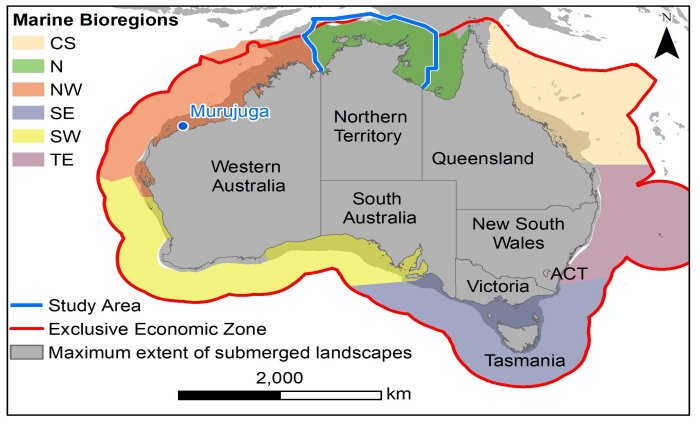
The study area relative to the main terrestrial and offshore regions of Australia, based on state and marine bioregions. Contains GEBCO 15 ArcSecond raster data (Public Domain) and Maritime Boundaries Geodatabase: Maritime Boundaries and Exclusive Economic Zones (200NM) (version: 11) (CCBY 4.0). CS = Coral Sea; N = North; NW = North-West; SW = South-West; SE = South-East; TE = Temperate East. Credit: Dr John McCarthy in Australian Archaeology
The study area relative to the main terrestrial and offshore regions of Australia, based on state and marine bioregions. Contains GEBCO 15 ArcSecond raster data (Public Domain) and Maritime Boundaries Geodatabase: Maritime Boundaries and Exclusive Economic Zones (200NM) (version: 11) (CCBY 4.0). CS = Coral Sea; N = North; NW = North-West; SW = South-West; SE = South-East; TE = Temperate East. Credit: Dr John McCarthy in Australian Archaeology

The Deep History of Sea Country (DHSC) project team has uncovered a new intertidal stone quarry and stone tool manufacturing site, as well as coastal rock art and engravings, during a land-and-sea archeological survey off the Pilbara coastline in Western Australia (WA).

The findings have been published alongside a separate study focused on the Northern Territory which identified underwater environments dating back to the Pleistocene that could provide important environmental and cultural insights into ancient Indigenous migration, land use, and early occupation of Australia.

The findings outline the need for a national policy that ensures resource companies operate with care for Aboriginal heritage and develop protections against climate change, dredging, windfarms, interconnectors, and seabed mining while ensuring industry collaborates with Indigenous stakeholders and archeologists.
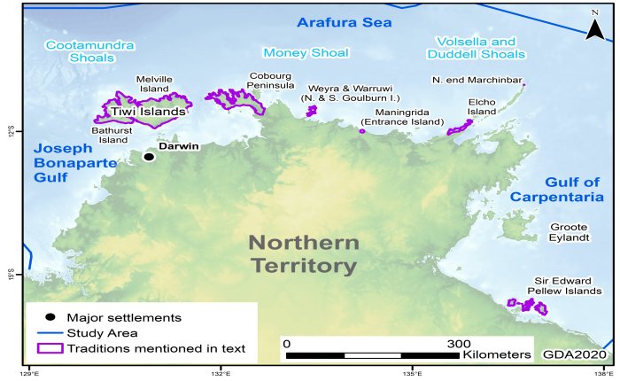
Locations of oral traditions with possible connections to sea-level change recounted by Aboriginal communities in the Northern Territory. Credit: Dr John MccArthy in Australian Archaeology. Topography and bathymetry from the SRTM30-plus v 8.0 via the eAtlas service, CC BY 4.0

Locations of oral traditions with possible connections to sea-level change recounted by Aboriginal communities in the Northern Territory. Credit: Dr John MccArthy in Australian Archaeology. Topography and bathymetry from the SRTM30-plus v 8.0 via the eAtlas service, CC BY 4.0

Aerial, landscape, and ground surveys of North Gidley Island and Cape Bruguieres in Western Australia represent fresh evidence of cultural heritage where hundreds of submerged ancient stone tools made by Aboriginal people, dating back to more than 7,000 years ago, were discovered.

The team has yet to determine the exact age of the sites found on the intertidal zone and fully submerged channel, but the results demonstrate a promising way forward to study the integrated landscape above and below the waterline.

“The challenge we now face for Australian submerged heritage is to extend the discoveries made at Murujuga to other areas, both in the land and seascape around these sites, but also across the Australian continental shelf” says ᴀssociate Professor Jonathan Benjamin, who is the Maritime Archaeology Program Coordinator at Flinders University’s College of Humanities, Arts and Social Sciences.
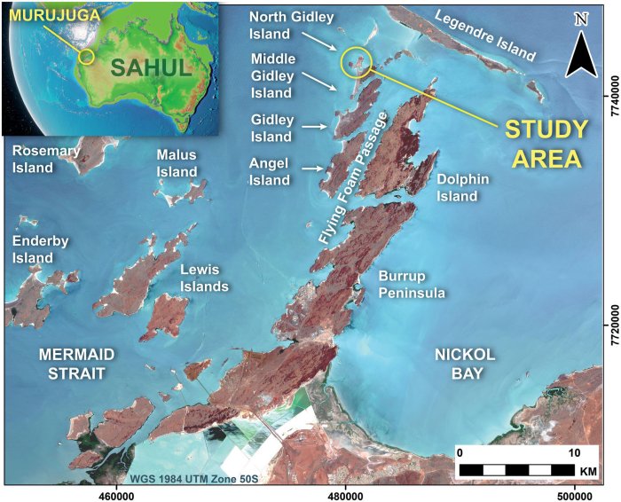
The islands of Murujuga, showing the location of the study area. The extent of the sub-aerially exposed land. Copernicus Sentinel data 2016 for Sentinel data. Credit: Leach et al in Australian Archaeology

The islands of Murujuga, showing the location of the study area. The extent of the sub-aerially exposed land. Copernicus Sentinel data 2016 for Sentinel data. Credit: Leach et al in Australian Archaeology

“We need to better understand and manage this underwater cultural heritage through local and national approaches. We must consider the very different scales of research, from ‘big data’ down to the boots-on-the-ground and snorkels-in-the-mouth as we comb Australia’s coasts, intertidal zones and submerged environments to record new archeological sites.

See also: More Archaeology News

Submerged sites are highly likely to be discovered around the continent, and down to depths as great as 130 meters.”

An international team of archeologists from Flinders University, The University of Western Australia, James Cook University, ARA—Airborne Research Australia and the University of York (United Kingdom) collaborated in partnership with the Murujuga Aboriginal Corporation to produce novel aerial and intertidal surveys of the cultural landscape in WA.

Paper

Written by Conny Waters – AncientPages.com Staff Writer
Related Posts

Andalusia Was First Inhabited By Neolithic People From The Southern Part Of The Iberian Peninsula 6,200 Years Ago

Andalusia Was First Inhabited By Neolithic People From The Southern Part Of The Iberian Peninsula 6,200 Years Ago

Conny Waters – AncientPages.com – The island of San Fernando, Cadiz in Andalusia, was home to the first Neolithic farmers and shepherds who decided to permanently settle there around 6,200 years ago. They practised shellfish collection and consumption all year round, with a preference for winter. Location of Campo de Hockey site in southern Iberian […]

Unknown Bronze Age Settlement Discovered Accidently In Heimberg, Switzerland

Unknown Bronze Age Settlement Discovered Accidentally In Heimberg, Switzerland

Jan Bartek – AncientPages.com – Sometimes, when archaeologists look for one thing, they find something entirely different. This is exactly what happened in Switzerland when researchers were excavating, hoping to find an ancient Roman brick workshop, but they unearthed a previously unknown Bronze Age settlement instead. The excavation in Heimberg, on the right edge of […]

Unexplained Mystery Of The Dangerous Invisible And Unidentifiable Enemy In A French Town

Unexplained Mystery Of The Dangerous Invisible Enemy In A French Town

Ellen Lloyd – AncientPages.com – It was an ordinary day in a small, sleepy town in France. There were no indications anything strange was about to happen. Yet, an inexplicable and extraordinary event left the unsuspecting residents completely bewildered and unsure of what was unfolding. The situation that unfolded was indeed unusual, if not bizarre. […]

Rare 2,800-Year-Old Assyrian Scarab Amulet Found In Lower Galilee

Rare 2,800-Year-Old ᴀssyrian Scarab Amulet Found In Lower Galilee

Jan Bartek – AncientPages.com – Erez Avrahamov, a 45-year-old inhabitant of Peduel, made an incredible discovery while hiking in the Tabor Stream Nature Reserve located in Lower Galilee. He stumbled upon an ancient seal shaped like a scarab that dates back to the First Temple period. Credit: Israel Antiquities Authority This ancient artifact is as […]

Dinas Powys: Late ‘Antique Hillfort Phenomenon’ In Post-Roman Western Britain

Dinas Powys: Late ‘Antique Hillfort Phenomenon’ In Post-Roman Western Britain

Conny Waters – AncientPages.com – Dinas Powys, Glamorgan, located about 9km southwest of Cardiff, is a small inland fort of approximately 0.35ha. The hillfort was first excavated by a team of archaeologists led by Leslie Alcock from 1954 through to 1958. The site is often referenced as a prime example of elite settlements in post-Roman […]

Puzzling Vasconic Inscription On Ancient Irulegi Hand Resembles Basque Language

Puzzling Vasconic Inscription On Ancient Irulegi Hand Resembles Basque Language

Jan Bartek – AncientPages.com – A few years ago, archaeologists excavating an Iron Age site known as Irulegi in northern Spain discovered a flat bronze artifact shaped like a human hand. After careful cleaning, they found it bore inscriptions of words from a Vasconic language. This language family includes Basque and several other languages that […]