Jan Bartek – AncientPages.com – Inhabitants of the sacred city of Caral were skilled architects, builders, and astronomers who studied celestial objects with great interest. Scientists have discovered pyramidal buildings, and other monuments in Caral were astronomically aligned to keep track of time so people could perform rites and ceremonies. Everything indicates the Moon was of special interest to the ancient Caral civilization.
Caral is America’s oldest city, and its age is comparable to the early civilizations of Mesopotamia, Egypt, China, and Mesoamerica.
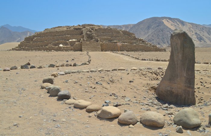
A pyramidal building in what was once the city of Caral. Credit: Adobe Stock- Mark
Located in Peru, the sacred city of Caral was once inhabited by the Norte Chico civilization whose people built “impressive pyramids that rise high above the ground, a sunken circular plaza, an amazing amphitheater, and public gathering places.
The pyramids of Caral were built as early as about 2600 BC. The construction of these buildings is estimated to have continued until about 2000 BC. This makes them of age comparable to the Pyramids of Giza and Cheops in Egypt, built between 2600 and 2480 BC.
Architects and engineers seeking solutions for sustainable living in the 21st century carefully study the remains of the ancient city of Caral in Peru, an engineering wonder built approximately 5,000 years ago.
Agriculture And Astronomy In The Sacred City Of Caral
Caral’s builders created a city of pyramids, sunken amphitheaters, seismically resilient buildings, and underground ducts that channeled the wind to keep their fires burning all with basic tools.” 1
Scientists have now studied several monuments constructed by the Caral-Supe culture of Peru and established the relation between the position of the structures, their orientations, and some astronomical and topographic features, which opens the way to the analysis of the way the inhabitants of this valley conceived space and time 5000 years ago.
The study conducted by a team of researchers, led by the Insтιтuto de Ciencias del Patrimonio (Incipit-CSIC) and the Insтιтuto de Astrofísica de Canarias (IAC), in collaboration with the team from the Arqueological Zone of Caral (Perú) led by Dr. Ruth Shady Solís provides new information how daily life depended on the cycles of the Moon.
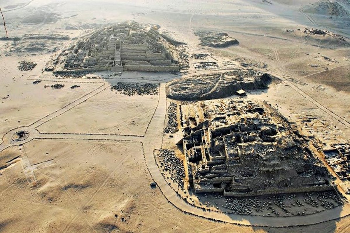
The valley of the river Supe in Perú contains the first evidence for city building in the Americas. In recent decades in this valley and in the nearby coast, numerous ceremonial sites have been found, with elaborate pyramidal buildings, and large circular open spaces which date back to 3000 B.C.
The society which constructed these buildings was based on agriculture using irrigation, notably cotton and pumpkin, and on fishing as the coast gives access to one of the richest fisheries in the world.
Towards the end of 2016, a campaign of field work was carried out in the Supe valley, taking measurements of the positions and orientations of the more important buildings of this very ancient civilization at the ten most important sites in the valley.
“The results of the research in the position and the orientation of the main buildings show that the presence of the River Supe is the main determining influence on the orientation of the buildings because although they are not sited directly at the river, they are systematically parallel to it in a curious phenomenon, convergent with what was occurring at the same time thousands of kilometers away in Valley of the Nile”, explains Juan Antonio Belmonte, an IAC researcher who is an expert in cultural astronomy and a co-author of the article.
However, the analysis revealed that the situation within the valley also was determined by very suggestive and novel astronomical relations.
The Moon Was Studied By The Norte Chico Civilization
“A surprising fact, never previously ascertained with comparable certainty is that the most important orientation pattern of these buildings coincides with that of the meridional risings of the Moon, which would coincide with full Moon around the June solstice, and in particular with its southernmost point, which is known as the major lunastice.
It is noteworthy that these orientations can be related to the precipitation cycles on the Andean summits, with the consequent beneficial floodings of the river, and thus with the agricultural cycles.
That time also coincided with the end of the fishing season, taking place over a wide area of the nearby coast”, explains César González-García, a researcher at the Incipit-CSIC and first author of the article.
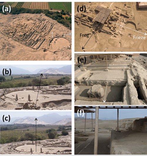
Examples of sunken circular plazas. (a) Aerial view of building A in Miraya. Note the change in size and orientation between the oldest (and largest, A) and newest (B) plazas. Whereas building A is facing toward Caral in the background (notice the top of buildings C and E of Caral in inset [b]) and the area where the southernmost moonrise would happen, the B plaza (c) is facing toward a different area, possibly related to the rise of the Southern Cross. (d) Building A1 in Vichama has two sunken circular plazas of different epochs. This building is famous for the appearance of the dancing figures in a frieze and the figure of a frog (e). The oldest plaza—white arrow in (d)—presents an orientation in coincidence with the direction of the frieze and the frog wall. The newest plaza, built at a later period, is not exactly perpendicular to the oldest one (f). The orientation of both plazas toward the southeast would coincide with the rising of Sirius, the brightest star in the sky, for the two periods of construction during the second millennium BC. (Color online). Credit: Latin American Antiquity
To be concrete, the orientation of these structures would indicate a strong relationship between these pyramidal buildings, which in many cases evoque the surrounding mountains, bringing them close to the urban area. But they also do this by connecting the orientations with the rhythms of the sky, which signal the correct times for performing the rites and ceremonies for celebrating the economic, agricultural, and fishing cycles.
In this way, these researchers claim, the monuments dating from the culture of the Supe valley five millennia ago are seen to be the first examples of the genuine interaction between landscape and skyscape in the civilizations of pre-Colombian America, which reached its high point millennia later with the Incas.
How Did The Ancient Civilization Of Caral Apprehend Space And Time?
In their study scientists explain, “it is important to realize that the monumental buildings created by this society may, in their location and spatial configuration, embed relevant information that may shed light on how the builders apprehended space and time.”
The City of Caral, located at km 182, north of Lima; in the Supe Valley. Credits: Turandino
Places can be regarded as centers with significant meaning for persons, whereas space can be understood as composed of places that create landscapes. This means architectural space can be interpreted as “the deliberate creation of space or as the space constructed by a society and its social relations. Where the social interaction takes place is important; therefore, place is not neutral but is loaded with value and power as defined by that society.
Finally, such a concept of space interestingly applies to where monuments are placed in the landscape and how they relate to their environment, how they “observe” and are observed, where they are facing, and their orientation.
See also: More Archaeology News
Thus, a direction of a monument has a concrete social meaning, and we can argue that the orientations embedded in a monument include valuable social information.”
The new study offers evidence the interaction between the local landscape and related astronomical phenomena played a role in the sacred city of Caral.
Written by Jan Bartek – AncientPages.com Staff Writer
Expand for references
- A. Sutherland – Sacred City Of Caral – Site Of The Oldest Known Civilization In The Americas, AncientPages.com
- González-García, A., Crispín, A., Solís, R., Ricra, J., Criado-Boado, F., & Belmonte, J. (2021). The River and the Sky: Astronomy and Topography in Caral Society, America’s First Urban Centers. Latin American Antiquity, 32(1), 154-172. doi:10.1017/laq.2020.88