Conny Waters – AncientPages.com – Pukaras (in Quechua and Aymara: ‘fortress’) are naturally impregnable settlements or strategic sites from 1000–1450 AD. They were defensive fortifications (or even fortified villages) built by the central Andean people from present-day Ecuador to the Chilean Central Valley and the Argentine Northwest.
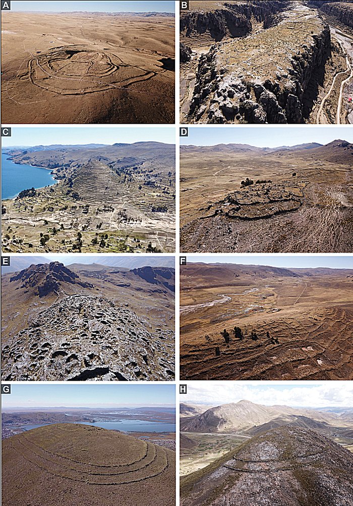
Pukaras in the survey area. Sites occupy hilltops (A, C, D, F, G, H), ridgelines (E), and high plateaus (B) with significant natural defences that include steep slopes, cliffs (B), and rock outcrops (D & E). Built defences, such as perimeter walls and ditches (A) are highly visible in satellite imagery. source
Pukaras are common structures in the landscape of the Andean highlands, but their distribution needs to be better known.
As the ground survey in the area is very limited, the researchers used a satellite imagery survey to cover an extensive area of 151,103 square kilometers in the south-central highlands of Peru.
Despite recent research, many questions still need to be answered about pukaras. It is known that these fortifications, varying in size, were used for defense and were strategically located on elevated terrains such as hills and ridges. Constructed defenses like walls, ditches, and natural barriers, including cliffs and steep slopes, further enhanced their security.
The defensive pukaras are characterized by one or more concentric walls on hilltops with minimal internal architecture or surface ceramics.
Their large, linear, and concentric arrangements of barriers and strategic hilltop positions make them exceptionally visible and distinctive in satellite imagery.
All surveys focused on highland areas above 2000m above sea level, where pukaras are more frequent.
Pukaras were recorded and ranked in the following groups:
1. pukaras, with unclear wall features;
2. pukaras with clear defensive arrangements but without visible residential structures;
3. high-pukaras with residential structures.
How effective was the satellite imagery survey in the researched area?
The survey could not detect every pukara. For example, thick vegetation often obscures visibility.
In their paper, the authors state:
“Even in regions with excellent visibility, naturally defensive landforms (e.g., mesas surrounded by cliffs) without substantial built defenses could not be identified as pukaras from satellite imagery alone unless the site contained visible signs of residential use or other architecture… Furthermore, pukaras located on low hills that have been farmed intensively since abandonment are harder to detect.”
Various changes usually affect the original landscape, so residential architecture has often disappeared, and defensive walls have been incorporated as terrace walls. Now, when such walls are modified or used for other purposes by the local population, they are much harder to distinguish.
However, they may be easier to recognize from the above than from an in-ground survey.
It is important to emphasize that the dataset obtained from combined satellite surveys is certainly not a complete census of every pukara in the surveyed region.
And yet, the obtained dataset has identified almost all pukaras with defensive features visible in high resolution (about 0.5m) satellite imagery.
Satellite surveys cannot capture less visible kinds of sites, so complete settlement patterns are not achievable through this method, which, according to the researchers, is seen as a complementary method to field research.
The paper states that Pukaras are densely concentrated in the Lake тιтicaca Basin and the Colca Valley, where previous field surveys had documented defensive settlement patterns.
The recent satellite survey also found considerable concentrations of pukaras in many other parts of the south-central Andes. In specific – very high-elevated areas – these structures appear to be absent or sporadic.
Most regions where they are found display a mix of residential and non-residential sites, but their prevalence and size vary significantly.
The largest pukaras are concentrated in the uplands to the south and south-east of Lake тιтicaca. On the other hand, smaller ones are concentrated around the northern margins of Lake тιтicaca and areas in the southern provinces of Cuzco located in the northwestern part of the survey area.
The researchers conclude that many fundamental questions regarding the pukara phenomenon in the highland Andes remain unanswered.
Despite almost two decades of archaeological investigation, more field research focusing on these constructions is needed to understand better patterns of residential and non-residential sites in which pukaras once played an essential role in the Andean societies.
Paper
Written by Conny Waters – AncientPages.com Staff Writer